
Check the acquisition promise
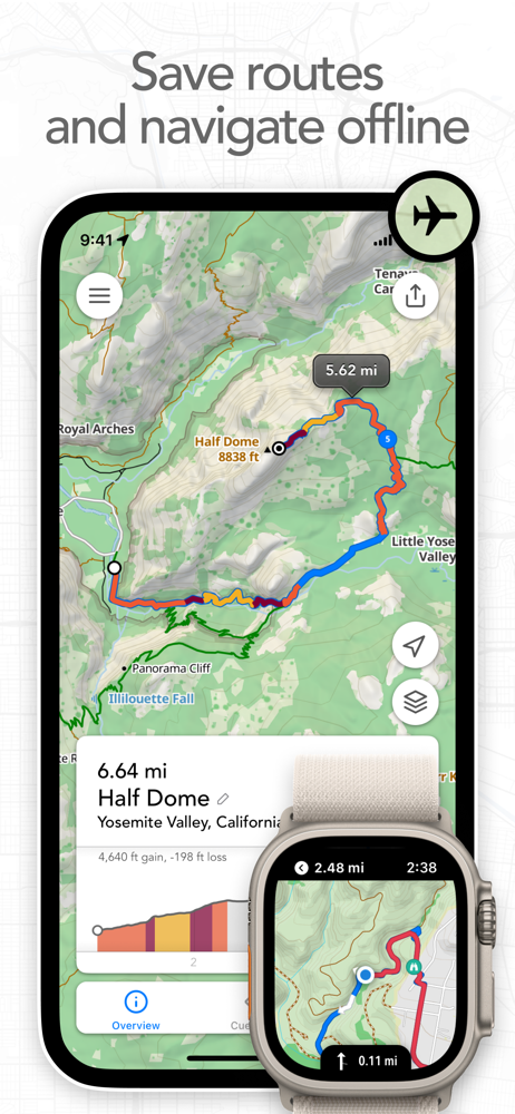
Read the store headline, screenshots and description. What problem is the app promising to solve?
Study the storefront ↗
Half Mile Labs LLC · iOS
Explore the ad evidence, study the storefront, and build your next acquisition hypothesis.
01 / Creative research
Read the store headline, screenshots and description. What problem is the app promising to solve?
Study the storefront ↗Explore apps with direct store-link matches. Compare their hooks and formats without assuming the same approach works here.
Browse observed advertisers ↗Store rankings and revenue estimates describe market context. They do not establish ad spend, conversions or ROAS.
Review the market context ↗02 / Storefront & product
Study the product story and store experience behind the acquisition funnel.



03 / Market context
Keep revenue, downloads and store rankings separate from advertising performance.
I have paid for and used about all of them for creating a route and adjusting on the fly but, this is the one. Only this app, not OSM, not Naviki, no Guru Mape, not Here, not Garmin, not Google, not Apple… and probably some others I am forgetting do what this app can do and is what I went through all the other apps looking for. At least in the USA only this app easily allows you to connect dedicated bike paths by simply clicking on the OpenCycleMap where you want to go. When you have to venture away from your planned route its interface makes that effortless. Draw with your finger and it will snap to the road and favor bike friendly. If the app snaps to something that you don’t want, click on the eraser until and draw that segment against. So on the side of the road or trail you can create a new plan in less than a minute. Here is the second best thing. It has unrivaled import and export features. More formats and more options to share.
I feel bad rating this too low because I did not use it for very long. However, that is because I started to get genuinely upset with it. It seems that it would be great for legitimate trails, city streets, etc. However, I had great difficulty getting it to stick to actual suburb roads. At one point it decided I should take a nice detour and bike through the pond. When drawing a simple path with a stylus, it thought it would be fun to throw in a few circles. Additionally, it did not give me sufficient editing abilities. On one trip I tried to map, it had a random straight line going through a woods. I attempted to erase it so I could shift it over, but it just kept reappearing in a different, equally incorrect location. It also completely ignores a popular footpath. The “snap to map” is somewhat a useful, and certainly an innovative feature. It just needs some love. I could see this working on longer trips that need less accuracy, but for my suburban 10 mile excursions it brought nothing but anger. For now, I’m going to stick to drawing vauge lines on a map, and finding out the mileage later. TLDR: I can see it’s applications and situations it could be good in. It just is not at all conducive to my biking or running excursions.
This app is absolutely fantastic for planning hikes. Even though we have used other online route apps, we've been looking for an easy to use route planning app for our phones that exports GPX route files for use with our favorite iPhone GPS software (GaiaGPS). Footpath does it seamlessly. We also upload the route files to fitness apps like RunKeeper where it tells us in advance how many calories our planned hikes will burn. Wonderful! Suggested future updates: add the ability to import existing GPX route/track files for easy sharing and editing (this is Footpath's most glaring deficiency in our opinion--right now you can only export routes to other apps); make it possible to easily move starting and mid-points of a route you want to edit (right now you can only edit an existing route by deleting segments of the route starting at the end until you get to a fork or turn you want to explore and then continuing along a new path from there); and it would also be great if your routes were automatically saved to a personal account on a website maintained by Footpath so they could be more easily managed and exported to your favorite GPS and fitness apps. All that said, Footpath is pretty awesome as is and has already benefited us greatly by giving us the ability to quickly and easily plan and execute our weekly hikes anywhere we are whenever we have a couple minutes. Thank you!
Map routes with your finger and Footpath will snap to roads and trails. Measure distances and elevations in seconds, then navigate along with turn-by-...
| Name | Price | Type |
|---|---|---|
| Single Route Pass | $1.99 | One-time |
| Footpath Elite (Monthly) | $3.99 | Monthly |
| Footpath Elite (Yearly) | $23.49 | Yearly |


