
$1.0K
Revenue
1.0K
Downloads
N/A
Rating
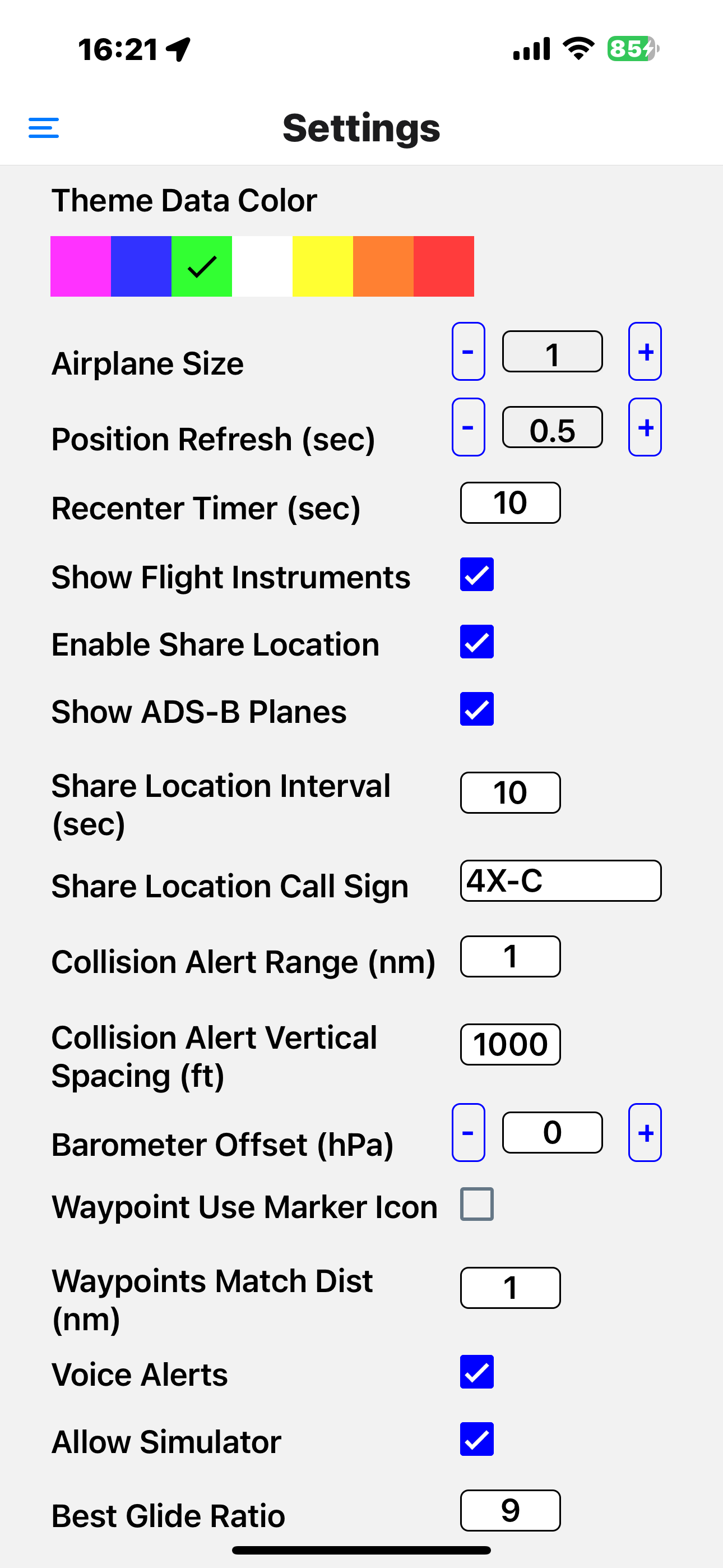
Screenshots


How Much Does Air Map Israel Make?
Monthly Revenue
$1.0K
Yearly Revenue
$12.0K
Per Download
$1.00
Platform Performance
🍎iOS
Revenue
$1.0K
Downloads
1.0K
Rating Distribution
N/A
☆☆☆☆☆
0 reviews
No rating data available
Top Countries
🇮🇱 IL🇺🇸 US🇫🇷 FR
Reviews (2)▼
★★★★★michakaufman4/15/2024
Game Over!
האפליקציה הזאת היא כל מה שצריך בתעופה הפרטית בישראל. יש בה יותר פונקציות מכל אפליקציית טיסה אחרת וקצב הפיתוח שלה מטורף. כמעט מידי יום נוספות לה יכולות, כולל יכולת שיתוף מקום, כל מפות התעופה (כללי, אזמ, מסוקים), הגשת מרשה טיסה, נוטאמים ועוד.
★★★★★dkuli3/24/2024
שמה את airnav pro בכיס הקטן.
התוכנה מצויינת. המפתח מגיב לכל רעיון, ומשפר את התוכנה. מהמסך העיקרי, מקבלים את כל מה שצריך כדי לטוס בישראל, כולל החלפת מפות, בקלות ומהירות. יש אפשרות להתגבר על חסימות ג׳יפיאס, התראת התנגשות ממטוסים אחרים שמשתמשים במפה. זו עומדת להיות האפליקציה שתכבוש את ישראל ללא ספק. (אם תישאר בחינם…)
Version History (154)▼
2.7.85/2/2026
2.7.74/27/2026
2.7.61/29/2026
2.7.51/21/2026
2.7.31/13/2026
2.7.21/5/2026
2.7.11/2/2026
2.7.012/31/2025
2.6.912/27/2025
2.6.812/3/2025
Available In (115 Countries)▼
🇺🇸 United States🇦🇺 Australia🇨🇦 Canada🇨🇳 China🇫🇷 France🇩🇪 Germany🇬🇧 United Kingdom🇮🇹 Italy🇯🇵 Japan🇰🇷 South Korea🇷🇺 Russia🇩🇿 DZ🇦🇴 AO🇦🇷 Argentina🇦🇹 Austria🇦🇿 AZ🇧🇭 BH🇧🇧 BB🇧🇾 BY🇧🇪 Belgium🇧🇲 BM🇧🇷 Brazil🇧🇬 Bulgaria🇨🇱 Chile🇨🇴 Colombia🇨🇷 CR🇭🇷 Croatia🇨🇾 CY🇨🇿 Czech Republic🇩🇰 Denmark🇩🇴 DO🇪🇨 EC🇪🇬 Egypt🇸🇻 SV🇫🇮 Finland🇬🇭 GH🇬🇷 Greece🇬🇹 GT🇭🇰 Hong Kong🇭🇺 Hungary🇮🇳 India🇮🇩 Indonesia🇮🇪 Ireland🇮🇱 Israel🇰🇿 KZ🇰🇪 Kenya🇰🇼 KW🇱🇧 LB🇱🇹 Lithuania🇱🇺 LU🇲🇴 MO🇲🇬 MG🇲🇾 Malaysia🇲🇹 MT🇲🇽 Mexico🇳🇱 Netherlands🇳🇿 New Zealand🇳🇬 Nigeria🇳🇴 Norway🇴🇲 OM🇵🇰 Pakistan🇵🇦 PA🇵🇪 Peru🇵🇭 Philippines🇵🇱 Poland🇵🇹 Portugal🇶🇦 QA🇷🇴 Romania🇸🇦 Saudi Arabia🇷🇸 RS🇸🇬 Singapore🇸🇰 Slovakia🇸🇮 Slovenia🇿🇦 South Africa🇪🇸 Spain🇱🇰 LK🇸🇪 Sweden🇨🇭 Switzerland🇹🇼 Taiwan🇹🇭 Thailand🇹🇳 TN🇹🇷 Turkey🇺🇦 Ukraine🇦🇪 UAE🇺🇾 UY🇺🇿 UZ🇻🇪 VE🇻🇳 Vietnam🇧🇴 BO🇰🇭 KH🇪🇪 Estonia🇱🇻 Latvia🇳🇮 NI🇵🇾 PY🇦🇫 AF🇬🇪 GE🇮🇶 IQ🇱🇾 LY🇲🇦 MA🇲🇿 MZ🇲🇲 MM🇾🇪 YE🇧🇯 BJ🇧🇫 BF🇨🇲 CM🇨🇬 CG🇨🇮 CI🇯🇴 JO🇱🇦 LA🇲🇱 ML🇸🇳 SN🇹🇿 TZ🇺🇬 UG🇿🇲 ZM🇿🇼 ZW
Supported Languages (1)▼
English
App Details▼
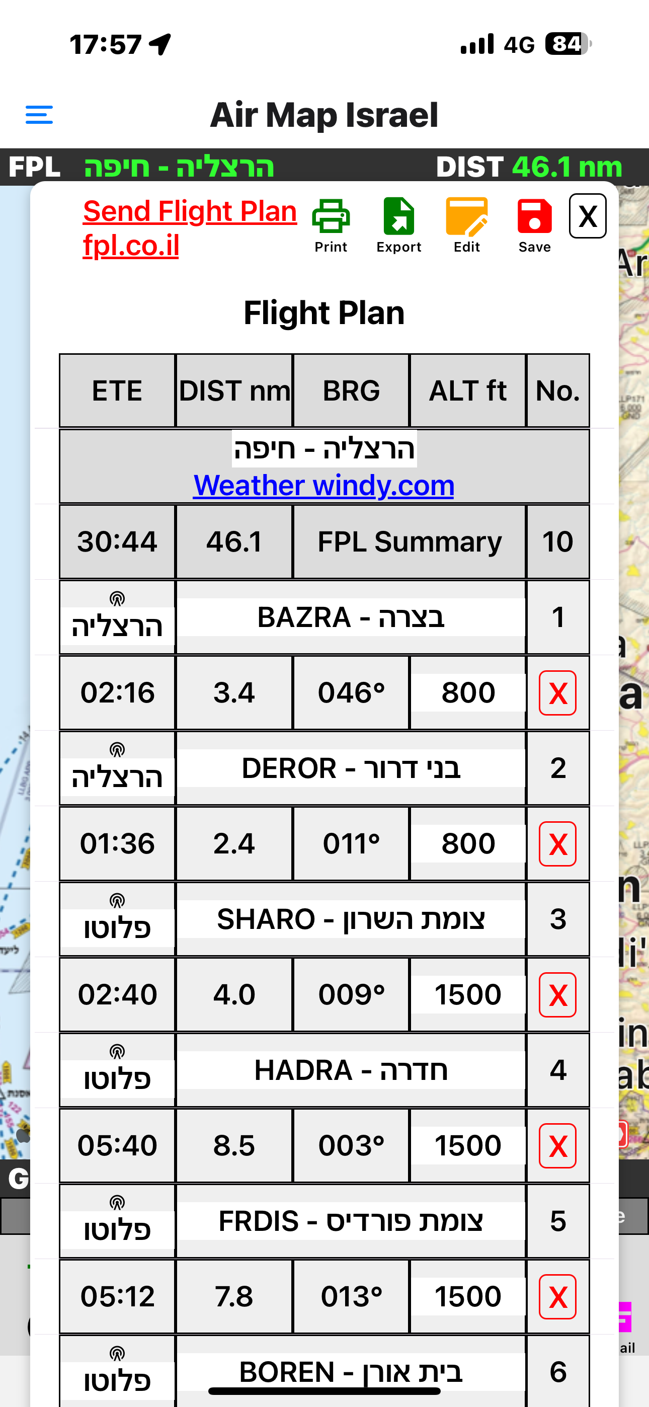
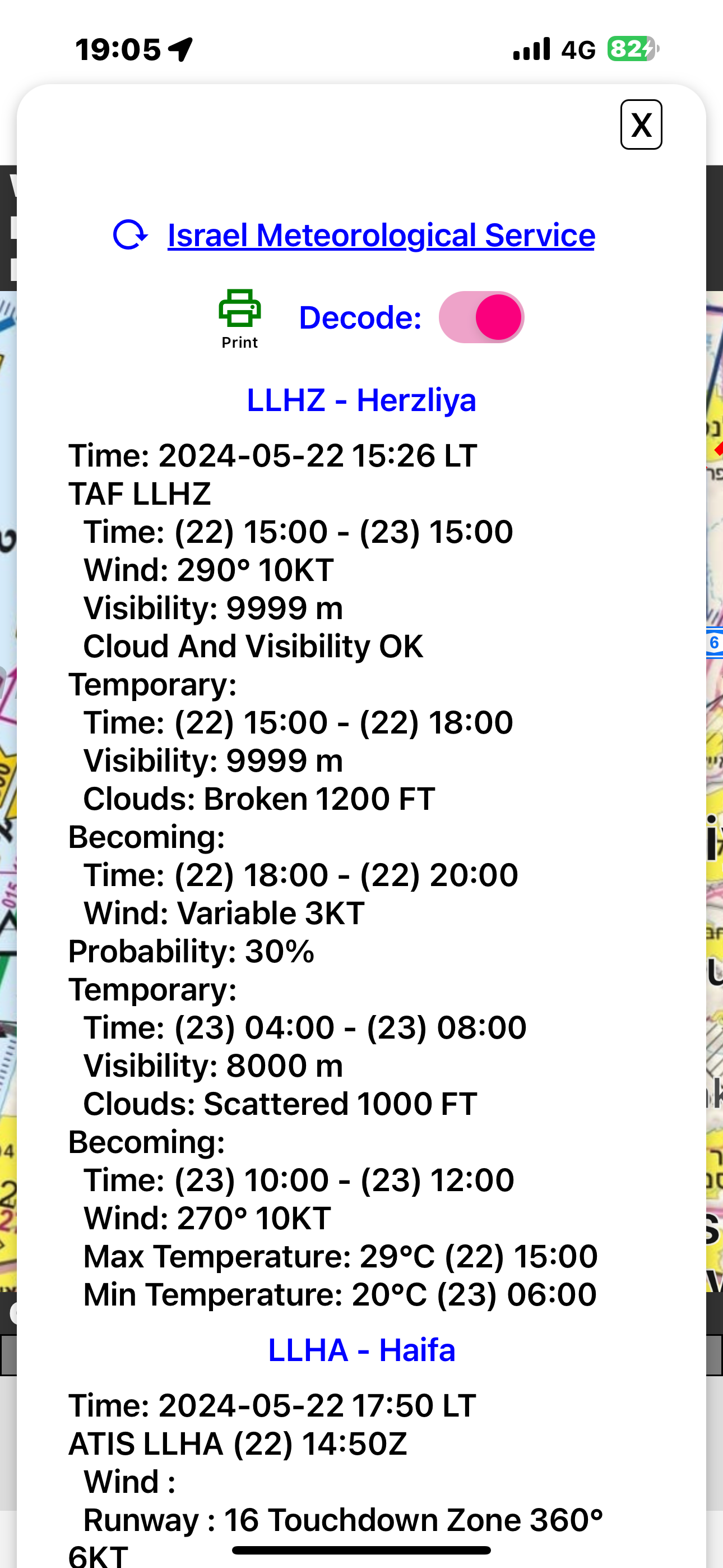
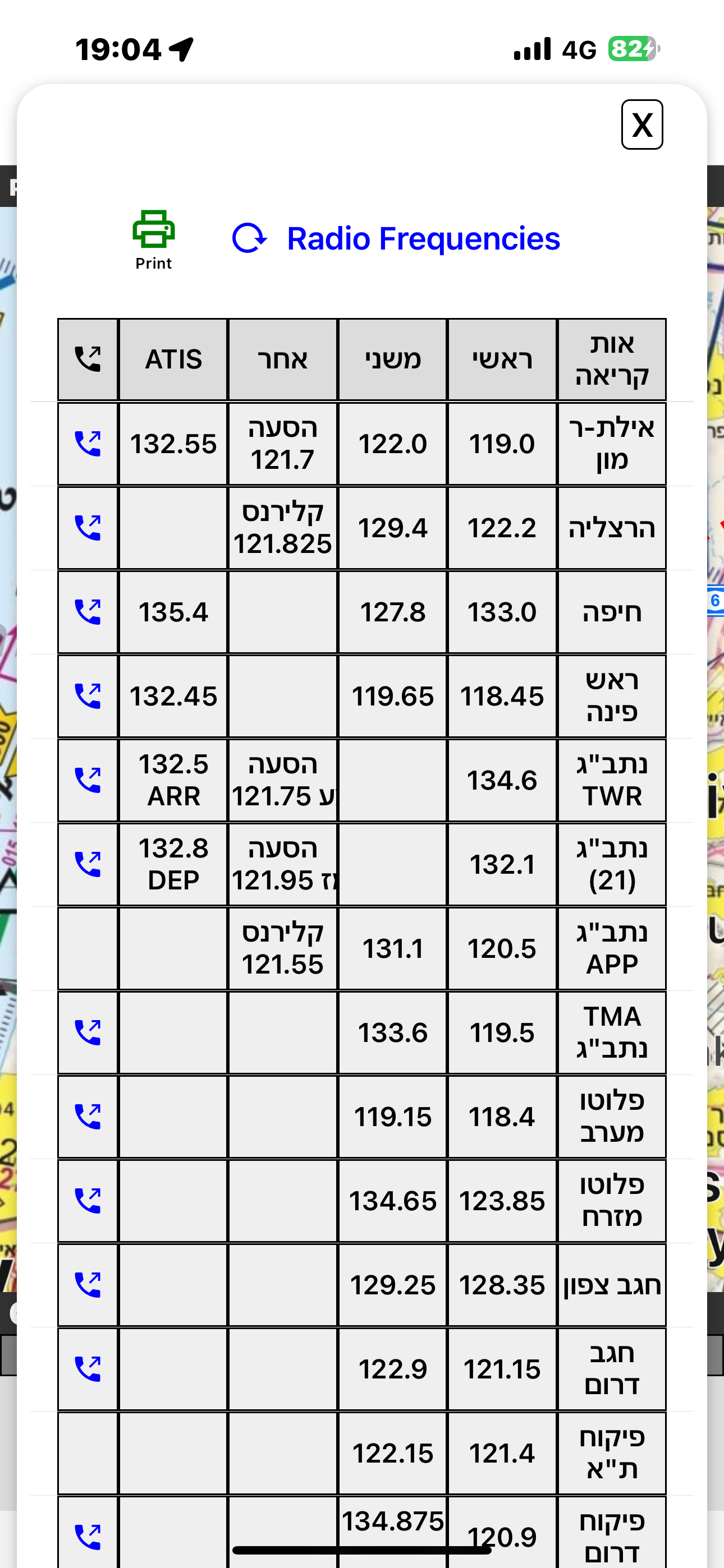
Air Map Israel is a navigation application for Controlled Visual Flight Regulation as an aid for pilots Visit us on https://sites.google.com/view/air...
Publisher
Ofer Raanan
In-App Purchases (2)
| Name | Price | Type |
|---|---|---|
| Support the APP Subscription (Monthly) | $4.99 | Monthly |
| Support the APP | $14.99 | One-time |
Similar Apps

Bike, Run, Hike Trails Mapeak
Mazor Harel

Israel Hiking Map
Mazor Harel

SkiDeal
Ronen Katz

PilotNavigation
A.M.Y.Z

DronesIL CAAI
Ministry of Transport - Civil Aviation Authority of Israel

A-EFIS Black and White
Charalampos Baltzakis
4.9 ★

Flight Navigation for Pilots
Free-Flight-Aviation Ltd.
4.8 ★

Air Navigation Pro
Xample Sarl
4.6 ★

Israel National Trail
Lior Boyango
4.5 ★

Air Navigation - VFR & IFR
Flygo-Aviation Ltd
4.4 ★