App Profile: Fires: Wildfire News and Atlas
Android / Games / Puzzles
Fires: Wildfire News and Atlas
Installs:
Rating:
4.61
Total Reviews:
11.35k
Top Countries:
US, AU, CA
< $5k
/mo
< 5k
/mo
Reviews: What People Think About Fires: Wildfire News and Atlas
oaktown_mark
Rating: 3/5
UPDATE: I got a "Developer Response" this morning telling me to check out the latest version of the app. The only problem is that the latest version is two months old and that's what I was running when the crashes on Launch started. This version of the app is NOT compatible with iOS 18, this was proven true on my iPhone 13 Pro and also on my new iPhone 16 Pro. I love this app and it's more straightforward than any other app of its kind that I've found. Please make it work again!
And it's been great and reliable for several years. Until I updated my iPhone 13 Pro to iOS 18.
Now the app crashes upon launching every time. It wasn't a hardware issue because the same issue persists in the new iPhone 16 Pro that I picked up and activated yesterday.
I love this app, please make it work again!
Knuckles049IH
Rating: 1/5
I’ve been using this app for a couple years and love it. I live in fire country and this app provides a needed service. I do not mind seeing ads in exchange for this service. But after a recent app update, I am now seeing invasive, full-screen ads that will not allow me to exit until they have completed the 5-second countdown. This is a serious problem and they need to update it to get rid of the invasive ads. When people are looking for vital safety information, they shouldn’t be forced to watch ads. Stick to the smaller ones that show up in the corners. I’m fine with those. Your users are here to view vital safety information. We are not playing a video game. Many people don’t have 5 seconds to waste while waiting for information about wildfires. I find this unsafe and disrespectful.
Driving machine 1
Rating: 5/5
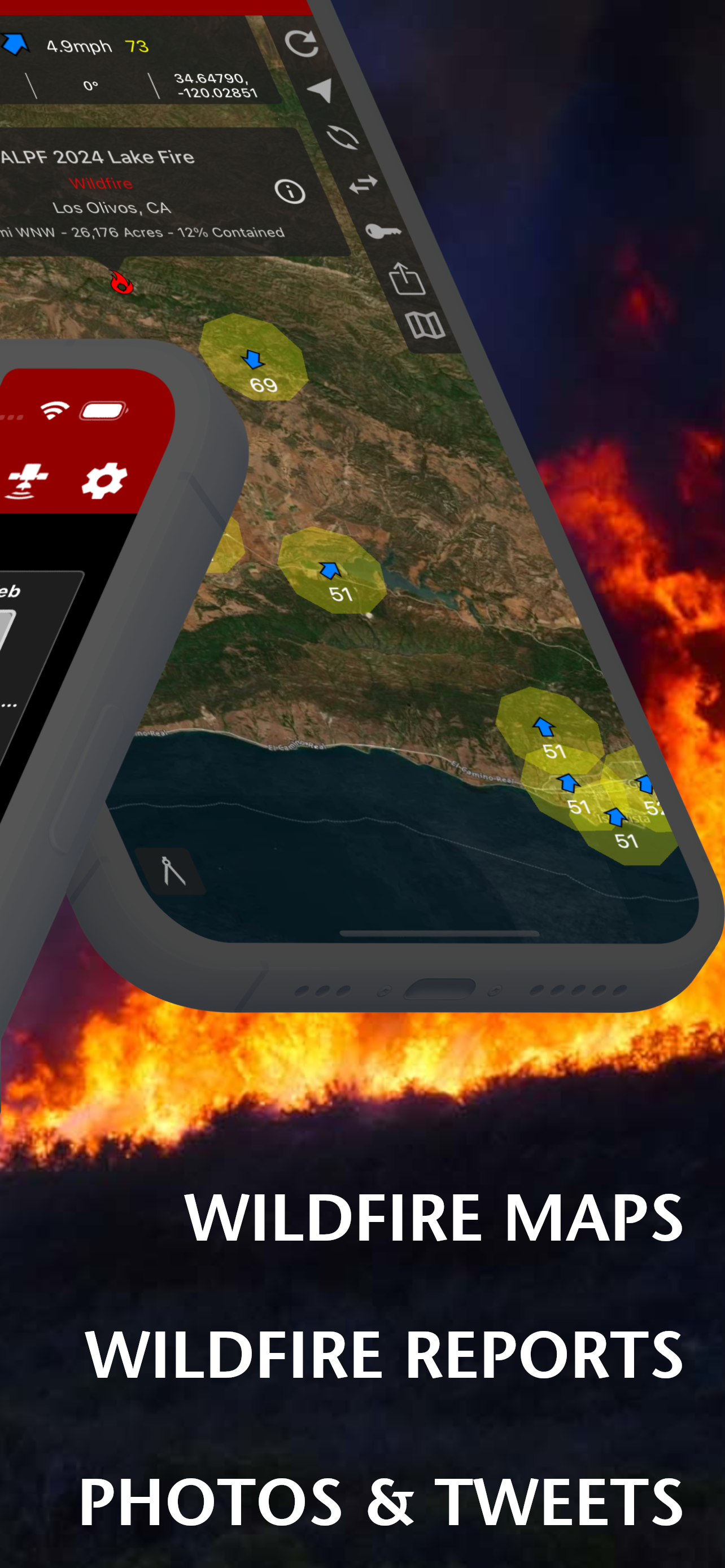
Very reliable data with easy to see maps.
I love the color satellite maps. They are updated daily at a minimum. In the spring I could make out areas that had an abundance of green growth, as well as areas of the mountains still covered in snow.
If a fire has a significant smoke impact, that is also visible on the satellite map.
Details include cause of fire when known and size and containment percentages.
Highly recommend this app!
About Fires: Wildfire News and Atlas
Stay informed and safe with the most trusted wildfire tracking app. Watch firefighting aircraft in real-time with 3D spheres and flight trails as emergency responders battle blazes. Used by first responders and millions worldwide.
REAL-TIME WILDFIRE & EMERGENCY TRACKING
Live aircraft tracking with color-coded missions and flight paths. Advanced 3D globe powered by WhirlyGlobe technology trusted by air traffic controllers.
- Live wildfire locations, perimeters, containment status
- Aircraft tracking with trails (blue=helicopter water drops, orange=air tankers, green=tactical command)
- Smart push notifications for nearby incidents
- Weather alerts on emergency maps
- Real-time evacuation zones and emergency alerts
- Power outage tracking (California only)
- Offline maps ensure access without cell service
OFFICIAL DATA SOURCES FIREFIGHTERS TRUST
- InciWeb - National Incident Information System
- CAL FIRE - California Department of Forestry
- NIFC - National Interagency Fire Center
- NASA FIRMS - Satellite fire detection
- NOAA - Weather conditions and imagery
- National Weather Service - Red Flag Warnings
- International - NSW RFS, CFA, QFES, CFS (Australia)
COMPREHENSIVE SAFETY INTELLIGENCE
- Global thermal hotspots and satellite imagery
- Real-time wind conditions and fire weather
- Critical weather alerts on emergency maps
- Air quality monitoring and smoke predictions
- Interactive 3D globe with atmospheric rendering
- 80+ offline National Forest and BLM maps
- High-resolution wildfire photography
FIRES ATLAS - PROFESSIONAL GRADE MAPPING
Transform your device into a professional firefighting tool with comprehensive offline mapping. Complete coverage of California, Oregon, Washington, Alaska, Arizona, Nevada.
WHY CHOOSE FIRES?
- Most Comprehensive - Global wildfire coverage with local detail
- Fastest Alerts - Real-time push notifications save lives
- Most Reliable - Offline capability when networks fail
- Professional Grade - Same data sources used by firefighters
Perfect for homeowners in fire-prone areas, outdoor enthusiasts, emergency preparedness, and professional firefighters.
SUBSCRIPTIONS
Subscriptions automatically renew unless auto-renew is turned off at least 24 hours before the end of the current period. Your iTunes account will be charged for renewal within 24 hours of the end of the current period, and identify the cost of the renewal.
Fires Pro Elite ($29.99/year)
Yearly access to the entire Fires Atlas, this includes unlimited access to all the Basemaps, BLM reference maps, and USFS reference maps.
- Access Incident Weather Conditions.
- Access Nearby Weather Conditions.
- Unlimited Global Weather Conditions using Waypoints.
Fires Pro ($14.99/year)
Yearly access to all the Basemaps along with yearly access to 4 BLM and USFS reference maps. Each reference map selection will last for 3 months at a time. After 3 months each reference map selection expires, then you can change that selection to any other reference map in the Fires Atlas.
- Access Incident Weather Conditions.
- 7 day free trial.
TO MANAGE YOUR SUBSCRIPTION:
- TURN OFF auto-renewal via the main Settings app: http://support.apple.com/kb/ht4098
- Subscriptions automatically renew unless auto-renew is turned off at least 24 hours before the end of the current period. Your iTunes account will be charged for renewal within 24 hours of the end of the current period, and identify the cost of the renewal.
- Your iTunes Account will be charged at confirmation of purchase.
- Visit the following URL to view our Privacy Policy: http://www.livewaremedia.com/p/privacy-policy.html
- Visit the following URL for full terms of use: http://www.livewaremedia.com/p/terms-and-conditions.html
File size: 57268224
Launched countries: IDUSAUCACNFRDEGBITJPKRRUDZAOARATAZBBBYBEBMBRBGCLCOCRHRCZDKDOECEGSVFIGHGRGTHKHUINIEILKZKEKWLBLTLUMOMGMYMXNLNZNGNOOMPKPAPEPHPLPTQAROSASGSKSIZAESLKSECHTWTHTNTRUAAEUYUZVEVNBOKHEELVNIPYMZYEBHCYMTBJBFCGJOLAMLSNTZUGZW
Minimum OS version: 15.5
Release Date: 1473320795000
Published by Ryan Strouse
Website url: http://livewaremedia.com
Publisher country: