MarineTraffic - Ship Tracking
MarineTraffic Applications LTDv4.2.6
Screenshots


How Much Does MarineTraffic - Ship Tracking Make?
Platform Performance
Rating Distribution
Top Countries
Rankings
Reviews (3)▼
As a newcomer to keelboat sailing, the Bay Area has a massive amount of traffic, both commercial and recreational. Keeping away from fast moving and massive,commercial traffic is really important and Marine Traffic is very helpful, particularly in low visibility situations, low light or even light fog. Those open ocean cargo ships from China or Japan are on the clock and in a hurry. From the recreational side, our sailing club has a number of more experienced sailors on larger boats with AIS and it’s often helpful to know where they are to help with cruising details such as speed over ground, course heading , docking details etc If you sail, even occasionally,in the dark or heavy fog or even heavy rain, you need this app.
This app does paywall a lot and I get that but you would think AIS is owned by these people when it’s tax payer funded and supported. I give credit by making an App that takes all the free data and puts it on a plate for you to enjoy and understand that cost money but at the end of the day most of what you sell is from a system funded by governments all over the world. It’s like the GPS system that the whole world uses but completely owned and operated in the US and paid for by the Americans. One huge issue is the misleading advertising and marketing. When you click on a ship updates it location via satellite instead of receiver it will ask if you want to add satellites to your app, if yes use Apple Pay for .99 cents. Apple Pay says it for satellites and a one time purchase so you feel like you are adding more to your plan to include satellite tracking but that’s not the case, nope. You are paying for the satellite tracking for that one ship for only 24 hours. Very shady how they did this and to be honest that data is reported to them for free (American taxpayers) I would even bet the satellites are American too.
I was looking for an app to track my vehicle shipment. This app does a great job of that and more. There’s a catch for free accounts, however. You get three “past route” and three “vessel info” unlocks before having to register and pay. No problem, I thought. Just want to track one ship over a period of 3-5 days. So day one I unlock the past route and vessel info for my ship. Very cool info! Day two I go to check on the vessel and… I have to use another unlock for both the past route and vessel info. Now day two again, but I closed the app and it wants to use my final unlock for both the route and vessel info. It’s the same ship on the same route. If you’re going to subscribe, this won’t matter to you. If you’re like me and only have a single, one-off use of the app, go for it but don’t close the app! You’ll have to use your limited unlocks again and quickly run out. I hope the app dev will consider allowing each unlock to last for the current sailing of the selected ship instead of what seems to expire as soon as I close the app.
Version History (56)▼
Available In (115 Countries)▼
Supported Languages (1)▼
App Details▼
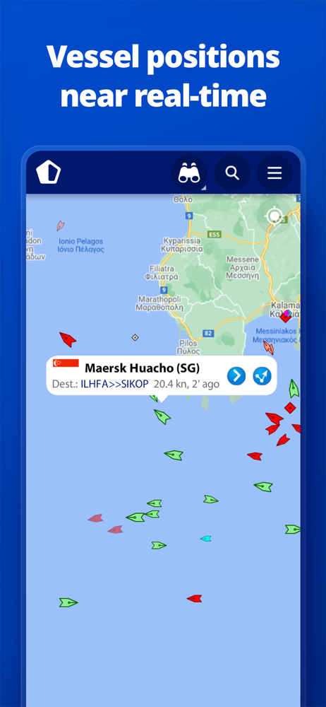
MarineTraffic displays near real-time positions of ships and yachts worldwide. Using the largest network of land-based AIS receivers, the app covers...
In-App Purchases (10)
| Name | Price | Type |
|---|---|---|
| Access Plus 24 | $0.99 | One-time |
| Advanced Density Maps Monthly | $1.99 | Monthly |
| Augmented Reality | $2.99 | One-time |
| Nautical Charts Monthly | $2.99 | Monthly |
| Nautical Charts Monthly | $6.99 | Monthly |
| Weather Maps Layers Monthly | $8.99 | Monthly |
| Starter Plan Annual | $9.99 | Yearly |
| Nautical Charts Annual | $29.49 | Yearly |
| Nautical Charts Annual | $66.99 | Yearly |
| Weather Maps Layers Annual | $95.99 | Yearly |
Similar Apps