App Profile: Compass 55. Map & GPS kit.

Android / Games / Puzzles
Compass 55. Map & GPS kit.
Installs:
Rating:
4.70
Total Reviews:
1.09k
Top Countries:
RU, US, TR
< $5k
/mo
< 5k
/mo
Reviews: What People Think About Compass 55. Map & GPS kit.
therockindoc
Rating: 5/5
I live in the desert and go target shooting frequently out in the desert with no GPS or roads. There are very specific locations such as holes in fences that one must be able to locate or, Otherwise, be very inconvenienced and, even worse, getting lost. This app is a blessing. By marking specific way points, it will take you right where you want to go with an arrow pointing in a very specific direction.
if you are having any difficulty figuring out how to properly use the app, Stan, the developer, is extremely kind and patient and will take the time to help you in great detail. Itβs not that the app is complicated to use, in fact, it is easy to use but I am an old fart and not very tech savvy. I highly recommend this app.
sandimacd
Rating: 5/5
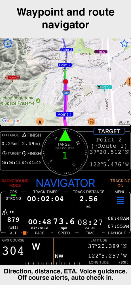
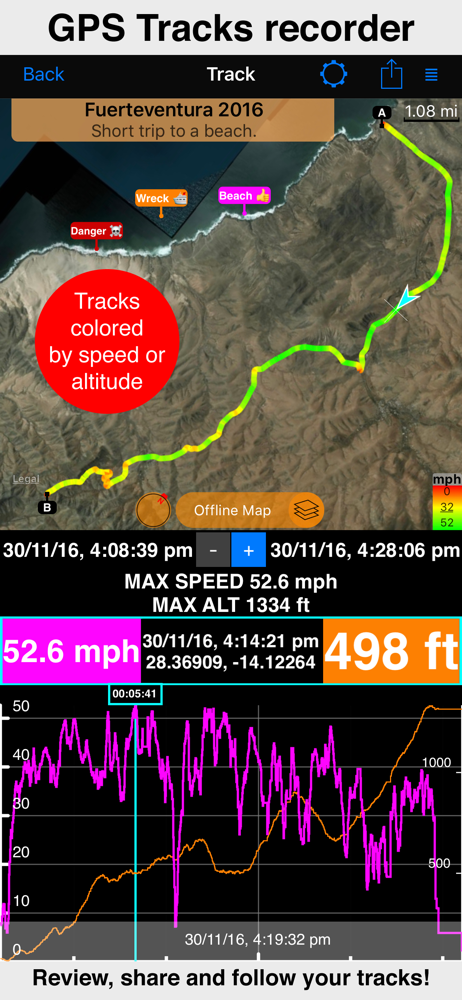
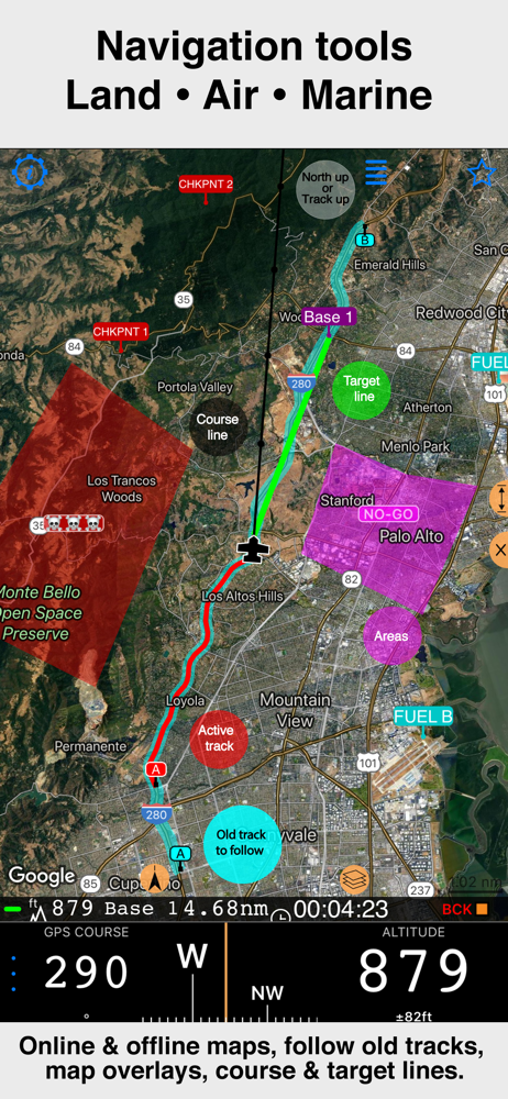
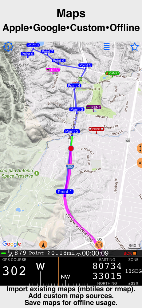
I am impressed when an app like this launches into a screen that explains setting options and how to use it including links to video tutorials. Was even more impressed by the unobtrusive star in the upper right window corner that will connect to the developer. Stan WANTS to help by directly responding to each inquiry.
He makes it clear what the $4 upgrade offers:
Pro pack enables following functions:
Google map for the main screen.
Blank map to avoid data/internet usage.
GPS track recording, sharing, pinning to a map and retracing.
Adding own/custom map servers.
Downloading maps for offline usage.
Multiple waypoint folders/collections and moving waypoints between them.
Showing ETA for the target navigation.
I have not yet upgraded and to date have not seen one advertisement after launching three times.
I sorted and read through the MOST critical reviews before downloading this app and saw where Stan responded to each. It's not often that the most critical reviews give a developer 4-5 stars. So I took the plunge. Am not disappointed in the least.
Lady ug1
Rating: 5/5
I wish I could give you guys more than 5 stars, I canβt say enough about this application, itβs everything you need and more. I travel a lot by car and it really puts me at ease knowing my location is being tracked and sent to a server. Also if your not too tech savvy, give yourself about 3 or 4 days to get the full benefit of what this app can do. Your missing out on using it to its full potential. Thanks guys
Terri
ONE OVERLY PLEASED CUSTOMER!!
ππππππππππππππππππππππππππππππππππππππππππππππππππππππππππππππππππβ¦..and many more stars kudos!!
About Compass 55. Map & GPS kit.
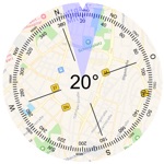
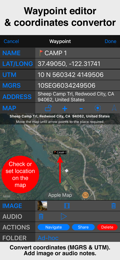
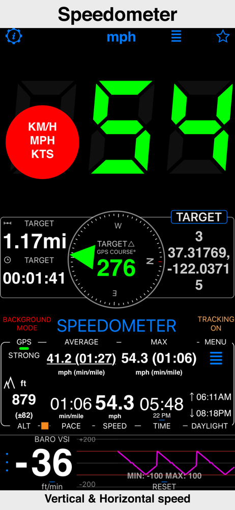
All-in-one assistant with a map, compass, GPS coordinates to view and share in 6 formats, altitude, distance, sunset/sunrise, speedometer with top and average speed, navigator to your target or along the route and a whole lot more!
+ Advanced target/waypoint editor. Can be also used as a coordinates converter. You can use map to check or set waypoint location and add photo or audio note.
+ Share your location via email, text message, Facebook or Twitter. This includes UTM, MGRS and Latitude/Longitude (MENU>Share my location).
+ You can use UTM, MGRS or Lat/Long, just pick your preference in settings (Coordinate Format).
+ Speedometer. Shows you the speed and pace. Speedometer also gives you options to control average and max speed and pace counters (MENU > RESET and PAUSE/RESUME counters).
+ Compass. Instant reaction compass, no delays. Automatically pickups the direction based on magnetic or GPS course. If you mostly walk or drive, you can change this automatic mode in app settings > Compass or GPS course. NATO mils? Same place in settings to set.
+ Magnetic declination Ξ΄ for the current location and any location on the map (via World Magnetic Model, WMM, no need for data/internet).
+ Sunset and sunrise. So you can plan your travel better.
+ Arrow pointing to your target waypoint. Distance and bearing to it.
+ Create/measure routes and areas.
+ Barometric Vertical Speed Indicator (VSI, IVSI) in both scale and graph forms.
+ Integration of bluetooth sensors: Cycling cadence, Heart rate, Cycling speed.
All above belong to a basic version. Lifetime PRO Pack upgrade will add following capabilities:
+ Recording and sharing GPS tracks.
+ Moving waypoints between folders.
+ Showing ETA to a target as this requires GPS tracking.
+ Native Google map with fantastic terrain map, amazing 3D and real night mode.
+ Adding own/custom tile map servers.
+ Downloading offline maps. Offline maps import in .sqlitedb, rmaps, mbtiles formats. Support for overzoom and underzoom - offline map is shown even for zoom levels that are not downloaded.
+ GPX import and export for waypoints, tracks and routes.
+ Google Earth KML support for waypoints and tracks import/export. KMZ support for waypoints and tracks export, waypoints import.
+ Ground overlays. Import KMZ ground overlay or draw your own on the map in the app and share as kmz files!
+ CSV import/export for waypoints.
+ Voice coach to tell you active track distance and duration, current speed and altitude without need to open the app.
+ Support for Siri shortcuts in IOS 12 for starting and stopping GPS tracks.
+ From version 4.2 - support for OSGB (including grid shifts) and SK 42 in the coordinates converter.
+ BACKGROUND MODE. App will work in background automatically when tracking. You can use other apps while Compass 55 does its job in the background!
+ PRIVACY. Compass 55 never shares your location data with 3rd parties or ad agencies. Location data is used solely for telling you direction to a target and recording GPS tracks and never leave the app unless you decide to share by means of a track export. It always lets you know when background mode is on and never runs in background unless the track is being recorded.
! You can use this app on your iPhone as well as on any cellular iPad. **App will not work properly on iPods and wifi only iPads as they don't have GPS (external GPS module is required). As quite a lot of us are using external GPS modules, app is available for wifi only iPads and iPods.
! Please note that as with all GPS apps, continued use of GPS running in the background can dramatically decrease battery life.
File size: 69907456
Launched countries: CAUSAUCNFRDEGBITJPKRRUDZAOARATAZBBBYBEBMBRBGCLCOCRHRCZDKDOECEGSVFIGHGRGTHKHUINIDIEILKZKEKWLBLTLUMOMGMYMXNLNZNGNOOMPKPAPEPHPLPTQAROSASGSKSIZAESLKSECHTWTHTNTRUAAEUYUZVEVNBOEELVNIPYKHMZYEBHCYMTBJBFCGJOLAMLSNTZUGZW
Minimum OS version: 15.6
Release Date: 1474599790000
Published by Kalimex-Consulting s.r.o. @Blocoware & Stanislav Dvoychenko
Website url: http://hdocs.blocoware.com/en/landnav/
Publisher country: