App Profile: Wind and Sea Med for iPad

Android / Games / Puzzles
Wind and Sea Med for iPad
Installs:
Rating:
0.00
Total Reviews:
0
Top Countries:
IT, FR, DE
< $5k
/mo
< 5k
/mo
Reviews: What People Think About Wind and Sea Med for iPad
Nevuchadnetzer
Rating: 1/5
Needed Thea app to monitor beach condition, mainly surf and swell hight (wave hight) which it did not have. From the limited preview on the app could not find out if this specific info was available. Ended up deleting the app. Would appreciate a refund, even though it's just $2.99. Thank you for your consideration.
About Wind and Sea Med for iPad
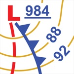
Wind & Sea Med is the APP that allows you to always have the famous LAMMA weather forecasts for sea and wind in the Mediterranean at your fingertips.
The point of force is its ease of use and consultation with accurate and detailed maps, but at the same time very intuitive, thanks to the choice of the color scale made by the LaMMA consortium.
Available models:
- Wave Height
- Wind at 10m
- Wind Gust
- Swell
- Wave Period
- Swell Period
- Precipitation and Cloud Cover
- Currents
- Sea Temperature (weekly forecast)
Available seas:
- Mediterranian Sea
- MED North Central
- MED South Central
- Western Mediterranian
- Eastern Mediterranian
- Ligurian Sea and Northern Tyrrhenian Sea
- Southern Tyrrhenian Sea
- Sardinia
- Sicily
- Ionian Sea
- Southern Adriatic Sea
- Northern Adriatic Sea
- Gulf of Genoa
- Gulf of Lion
- Balearic Islands
- Sardinia Channel
- French Riviera
- Corsica
- Tuscan Archipelago
- Strait of Bonifacio
- Pontines Islands
- Aeolian Islands
- Ustica
- Istrian Peninsula
- Tremiti Islands and Gargano
- Gulf of Taranto
- Corfu
- Greece
- Chalkidiki
- Greek Islands
- Crete
- Turkey
- Cyprus and Lebanon
Plus:
- Receive a notification when sea conditions deteriorate. You can choose the areas of your interest and the activation threshold on sea and wind scales.
- Save the forecasts to display the maps even in case of lack of signal. The saved maps can be used only for the period of validity of the forecast and only if there is no signal.
- Maps animation to control evolution of forecasts of next days.
- View of 2 maps simultaneously in portrait mode.
- View of 4 maps simultaneously in landscape mode.
- Zoom on a single map in landscape mode.
- On startup, displays the map at the current time.
- Legend of used scale for sea state, wind, rainfall and cloud cover.
- Share maps on Facebook, Twitter or by email, save maps to the Camera Roll.
Available in english, italian, french, german, spanish, catalan and also in slovenian (Sporočite nam v slovenščini na: [email protected] in bomo popraviti), croatian (Prijavite greške u hrvatskom jeziku na: [email protected], a mi ćemo ispraviti) and turkish (Türkçe dil hataları rapor: [email protected] ve biz düzeltiriz).
The forecast are updated twice a day.
FOR ANY PROBLEM DON'T HESITATE TO WRITE TO EMAIL ADDRESS OF REFERENCE
File size: 11102208
Launched countries: ITUSAUCACNFRDEGBJPKRRUDZAOARATAZBBBYBEBMBRBGCLCOCRHRCZDKDOECEGSVFIGHGRGTHKHUINIDIEILKZKEKWLBLTLUMOMGMYMXNLNZNGNOOMPKPAPEPHPLPTQAROSASGSKSIZAESLKSECHTWTHTNTRUAAEUYUZVEVNBOEELVNIPYKHMZYEBHCYMTBJBFCGJOLAMLSNTZUGZW
Minimum OS version: 15.6
Release Date: 1365644380000
Published by Daniele Fruzzetti
Website url: http://www.zoodany.it
Publisher country: Italy
Related Apps